Project Description
High coastal population growth rates, with associated water demand and environmental changes including climate change are putting enormous pressure on coastal groundwater resources. Groundwater is more resilient to increasing climatic extremes, and is the only source of water during droughts, but if over-extracted, is vulnerable to depletion and underground salinisation from the ocean.
In East Africa (EA), increased birth rates, development and migration from inland areas have increased demand for water and land leading to poor sanitation and water supply. Groundwater is often the only year-long reliable source of freshwater essential for sanitation, agriculture, and consumption but saline intrusion causes long-term contamination.
The UNESCO World Heritage property of Kilwa Kisiwani (KK), a small island off the coast of Tanzania, was once a particularly celebrated maritime city-state which dominated a large part of the Swahili coast during the late medieval period. KK was then a prosperous city with many mosques and palaces, described by the 14th-century explorer Ibn Battuta as, ‘the most beautiful of cities and elegantly built’. Various authors record KK had a population of between 4,000 and 30,000 in the 16th-century, which had declined to ~1,000 by the 19th-century, but is currently rising again to over ~1,200 people.
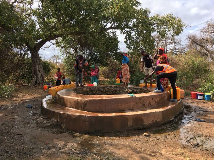
Archaeological evidence suggests that, after some time, the island’s freshwater could no longer sustain the sultan’s palaces, pilgrims to the mosques and seafaring traders. Today, the island has the remains of at least 17 stone-wells, most of which are abandoned or too salty to drink. Three are still in use though have higher levels of salinity than on the mainland. Previous well excavations on KK have shown the water table to be up to 2m higher in the 14th-century.
The multidisciplinary project will investigate how availability and quality of freshwater from wells contributed to the decline of KK at different stages of its history, and how water management can alleviate water shortages allowing local development of the EA coast and island communities.
The candidate will develop conceptual and numerical models of the freshwater aquifer of KK Island and surrounding coast, which will be used to analyse historic, present and possible future climate and demographic scenarios, including water use scenarios affecting KK during different periods of climate and prosperity, and to identify how much water can be taken from wells during rainy and dry seasons before the water becomes too saline. They will learn from and guide local people in freshwater management to determine good practice in coastal areas along the EA coast. The models will build on and integrate the extensive hydrological (groundwater levels, salinity, geophysics) and archaeological (well mapping, well use) data collected as part of previous research by the supervisory team, expand them through additional seasonal surveys.
The project would suit a numerate scientist with a first degree in earth science, hydrogeology, environmental science or a related discipline. The student will be a member of a vibrant team of PhD researchers at the host Universities and will gain hydrogeological fieldwork and modelling skills, relevant for industry or academic careers.
CANDIDATE BACKGROUND
Essential skills / experience: First degree in geology/geophysics, hydrogeology, physical geography, environmental science, or similar with a strong numerate component. Scientific writing and presentation experience. Strong organisation skills and motivation to tackle complex problems.
Desirable skills / experience: Geological/hydrological fieldwork experience; background and/or strong interest/experience in hydrogeology, hydrology, geospatial analysis, or a combination of these subjects. Experience in handling complex environmental datasets. Interest in historical heritage, archaeology, and community engagement.
Photo credit: Jean-Christophe Comte, UOA
Supervisors
Jean-Christophe ComtePrimary Supervisor: | Profile: Jean-Christophe Comte Email: jc.comte@abdn.ac.uk Institution: University of Aberdeen Department/School: School of Geosciences |
Will MegarrySecondary Supervisor: | Profile: Will Megarry Email: w.megarry@qub.ac.uk Institution: Queen's University, Belfast Department/School: School of Natural and Built Environment |
Joshua WrightAdditional Supervisor: | Profile: Joshua Wright Email: Joshua.wright@abdn.ac.uk Institution: University of Aberdeen Department/School: School of Geosciences |
Additional Supervisor: | Dr Elgidius Ichumbaki – University of Dar Es Salaam (Archaeology), Dar Es Salaam, Tanzania Dr Simon Melchioly – University of Dar Es Salaam (Hydrogeology), Dar Es Salaam, Tanzania Dr Edward Pollard – The Discovery Programme, Centre for Archaeology and Innovation Ireland Dr Alan MacDonald – British Geological Survey (Hydrogeology), Edinburgh, UK |
References
- Comte, J-C., R. Cassidy, J. Obando, N. Robins, K. Ibrahim, S. Melchioly, I. Mjemah, H. Shauri, A. Bourhane, I. Mohamed, C. Noel, B. Mwega, M. Makokha, J-L. Join, O. Banton, J. Davies (2016) Challenges in groundwater resource management in coastal aquifers of East Africa: Investigations and lessons learnt in the Comoros Islands, Kenya and Tanzania. Journal of Hydrology Regional Studies 5: 179-199.
- Pollard, E. (2012) Present and past threats and response on the east coast of Africa: an archaeological perspective. Journal of Coastal Conservation 16 (2): 143-158.
- Heron, S., J. Day, M. Mbogelah, R. Bugumba, E. Abraham, M. Bakari Sadi, N. Pauline, M. Said Khamis, S. Madenge, W. Megarry (2022) Application of the Climate Vulnerability Index for the Ruins of Kilwa Kisiwani and the Ruins of Songo Mnara, Tanzania. Dar es Salaam: CVI Africa Project.
QUADRAT Themes
- earth-systems
- environmental-management
Partners
Collaborators will include:
- University of Dar Es Salaam, Tanzania
- The Discovery Programme, Centre for Archaeology and Innovation Ireland
- British Geological Survey