Scott Angus, Research Experience Placement student
BSc. Physics
Supervised by Dr Lydia Sam and Dr Anshuman Bhardwaj
Back in June, amidst the turmoil of the ongoing COVID-19 pandemic, I received an email from the NCS School office about the NERC QUARDAT DTP research experience placements that were running. Having just found out that my summer industry job had been cancelled, I looked through the research proposals and found a project that really interested me. The opportunity to contribute to research whilst working remotely this summer was too good to miss out on and was hugely beneficial in teaching me new skills, as well as providing me an insight into a new area of study.
The project I applied for was titled “Geostatistical analysis of spatiotemporal trends of COVID-19 spread in UK” which was a very exciting prospect because of how topical and world-changing the Coronavirus pandemic has been. It also allowed me to further explore an area of research I was already interested in (statistical and mathematical modelling) from a different angle through working with the School of Geosciences at the university.
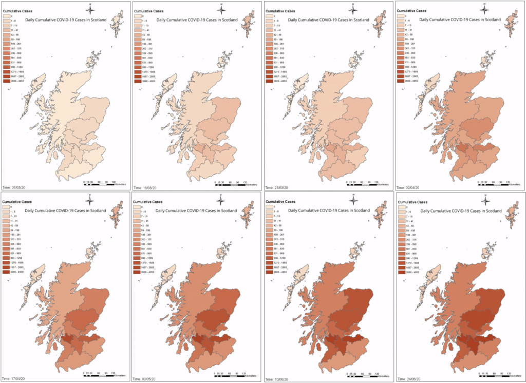
During the 10-week project, I had to gather and compile all the daily COVID-19 data from the devolved governments and compile it into various datasets so that we could perform geospatial analysis of the hotspots using ArcGIS. This was something I really enjoyed and found very beneficial as I had never worked with ArcGIS before but my two supervisors were so helpful in teaching me not only the skills I needed for the project but skills that I would be able to apply to future projects using the same tools. In addition to the geospatial analysis, we also performed statistical analysis on the data to evaluate the effectiveness of the various non-pharmaceutical interventions put in place by the government as well as create mathematical models to simulate the effect of introducing the measures at different points in time and how the cases and fatalities might have differed. It was in this part of the project that my experience in maths and physics was very useful as I was able to create the models in R and write a program to automate the statistical tests which saved a lot of time.
Throughout the project we met twice a week (virtually!) to discuss any issues that had arisen and work out possible solutions as well as share the most recent results. By the end of the project, we had produced a very comprehensive set of maps detailing the spread of cases throughout the UK, broken down by population density, demographic and local council area, as well as showing the hot and cold spots of the disease and the effects of the various NPIs.
Overall, the NERC-QUADRAT research experience placement was hugely beneficial as it allowed me to work closely with another department in the university which taught me a lot of new and very useful skills, especially to do with ArcGIS and hotspot analysis, as well as providing the opportunity to contribute to research which will hopefully help implement more effective measures in future pandemics. I would recommend the summer placement scheme to anyone who is interested in applying their skills in a different field to what they are used to as it showed me a whole new approach to research and inspired me to undertake a similar project in my honours year of my degree.