Project Description
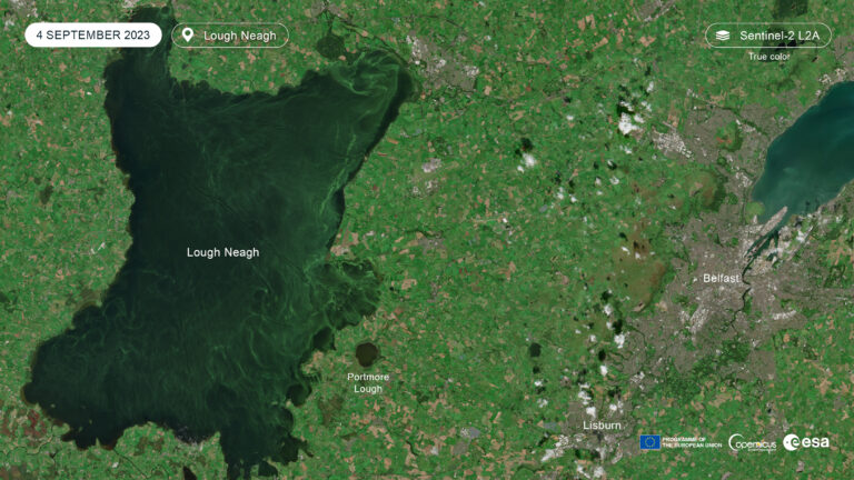
Harmful algal blooms (HABs), principally cyanobacteria population explosions, are an increasing global problem due to agricultural runoff and nutrient enrichment of freshwaters, increased surface water temperatures due to climate change and ecosystem mismanagement with notable impacts in North America, China and elsewhere (Hallegraeff et al. 2021). Lough Neagh is the UK and Ireland’s largest freshwater lake and in recent years has been subject to a series of harmful algal blooms. The 2023 cyanobacteria (Microcystis species) bloom was unprecedented in the UK and Ireland in terms of its scale, duration and impact with the entire 392km2 of the lake’s surface affected receiving widespread media attention. Lough Neagh is ecologically and economically important: designated for its wildfowl populations, site of Europe’s largest commercial eel fishery, home to pollan (Coregonus pollan) an endemic white-fish listed as Endangered and host to numerous businesses. Remote-sensing using satellite imagery and Geographical Information Systems (GIS) will provide a means by which to characterise and describe harmful algal blooms in terms of their temporal frequency and amplitude, as well as their spatial structuring allowing the drivers of such events to be determined. This project will utilise multiresolution datasets, for example, Landsat, SPOT, ASTER, MODIS, PlanetScope, Hyperion, PRISMA, or Copernicus Sentinel satellite imagery to create a time-series of images of Lough Neagh from the start of the satellite era (ca. 1970s) to present. These will be used to:
a) characterise seasonal fluctuations and annual planktonic cycles using multispectral and hyperspectral characteristics of the satellite datsets, rises and falls in Normalised Difference Chlorophyll Indices (NDCI) and other characteristics, corresponding to harmful algal blooms, can be identified retrospectively determining their magnitude (standard deviations from the long-term mean), frequency (occurrence over time) and phenology (the start, end and duration of such events), for example, see Jia et al. 2019
b) analysis of potential drivers of such events i.e. modelling the influence of temperature (promoting algal growth) and rainfall (influencing agricultural runoff), surrounding land use (changes in land cover over time such as intensification of grasslands using surrounding Normalised Difference Vegetation Indices (NDVI), loss of riparian corridors (e.g. waterway hedgerows and tree lines), changing turbidity (low turbidity means better light penetration helping phytoplankton grow), as well as non-remotely sensed data such as sewage and wastewater treatment effluent releases, farm statistics i.e. the numbers of livestock in the catchment) and the impact of invasive species, specifically non-native zebra mussels (Dreissena polymorpha) which invaded the system in the early 2000s. The latter clarify the water column promoting photosynthesis whilst altering plankton communities in favour of cyanobacteria due to selective feeding. The annual NDCI cycle could be compared before-and-after invasion.
c) The spatial structure of the most recent bloom can be characterised (greatest algal biomass is observed in the East of the lake) to analyse factors influencing its heterogenous distribution i.e. wind, currents, and lake inputs from surrounding river catchments whose agricultural and water flow may vary allowing differential impacts on the lake ecosystem and ecology to be described.
Thus, Lough Neagh will act as a strategically important case study of the wider global problem of harmful algal blooms (see Anderson et al. 2019) with this project demonstrating the value of mining remotely-sensing to determine the drivers, and therefore potential solutions, to these devastating extreme events.
CANDIDATE BACKGROUND
Essential:
- Primary degree (2:1 or above) in Geoscience, Geographical Information Systems, Ecology or other allied subject area;
- Previous experience of Geographical Information Systems in a research context
- Excellent computer literacy
- Experience of statistical analyses
- Personal ambition, determination, tenacity, resilience and resolve.
Desirable:
- MSc in Geoscience, Geographical Information Systems, Ecology or other allied subject area with a previous Research Project involving GIS.
Image credit: European Environment Agency 2023
Supervisors
Neil ReidPrimary Supervisor: | Profile: Neil Reid Email: neil.reid@qub.ac.uk Institution: Queen's University, Belfast Department/School: School of Biological Sciences |
Anshuman BhardwajSecondary Supervisor: | Profile: Anshuman Bhardwaj Email: anshuman.bhardwaj@abdn.ac.uk Institution: University of Aberdeen Department/School: School of Geosciences |
Jennifer McKinleyAdditional Supervisor: | Profile: Jennifer McKinley Email: j.mckinley@qub.ac.uk Institution: Queen's University, Belfast Department/School: School of Natural and Built Environment |
References
- Hallegraeff et al. (2021) Harmful Algae 102: 101992 https://doi.org/10.1016/j.hal.2021.101992
- Jia et al. (2019) Remote Sensing 11(19): 2269 https://doi.org/10.3390/rs11192269
- Anderson et al. (2019) Front. Mar. Sci 6: 250 https://doi.org/10.3389/fmars.2019.00250
QUADRAT Themes
- biodiversity
Partners
To be confirmed