Project Description
Blanket bogs are important carbon sinks, which also regulate stream flow and water quality, as well as contributing to biodiversity. Despite this, they have experienced widespread disturbance, changing them from carbon sinks to sources of emissions, which contribute to national carbon footprints.
Across the UK and Ireland, bog restoration forms part of government climate change mitigation strategies. For restoration to be successful, an understanding of how hydrology, geology, and ecology interact on intact blanket bogs, and how they respond to disturbance, is needed. This in turn requires an ability to monitor large areas of blanket bog. However, many existing methods are limited to capturing information about small areas, over limited periods.
Geophysical methods have been used to investigate large areas of peatlands to link hydrology and geology to ecological processes. Although Ground Penetrating Radar (GPR) and Electrical Resistivity Tomography (ERT) allow investigation of peat thickness and groundwater flow, considerable scope remains to apply other methods. Seismic interferometry can be used to investigate changes in velocity of seismic waves over time. This has included monitoring groundwater[1], and water saturation changes in peatlands[2], indicating its potential to become a tool in monitoring the health of large areas of blanket bog.
This project will use established (GPR and ERT) and novel (seismic interferometry) methods to monitor near intact, and degraded peatlands at an existing research site in Co. Sligo, Ireland: Letterunshin[3]. Hydrological monitoring, undertaken at Letterunshin over the past five years has highlighted the need to better understand hydrological processes, including how peat pipes impact ecohydrology, how groundwater velocity varies over time, and how peatland condition impacts water quality and stream flow. Geophysical monitoring methods can provide essential information for addressing these questions.
This project will involve collection of GPR and ERT data at Letterunshin, in collaboration with existing American and Irish researchers. Information collected will be used to refine existing geological models and, through comparison with hydrological data, better determine how geology controls hydrology. Findings will guide seismometer deployment to develop seismic interferometry for monitoring peatlands. Broadband seismometers will be deployed for at least 1 year, distinguishing daily and seasonal changes in hydrology, including responses to extreme hydrological events. Seismic and hydrological data will be compared, including those from areas near peat pipes, and areas of highly variable groundwater flow velocity. More generally, research will assess the suitability of seismic instrumentation for monitoring peatlands, providing recommendations for future studies.
The project has scope to expand these methods used to other settings and areas, already accessible to project supervisors. This includes sites where restoration efforts are on-going, allowing evaluation of the effectiveness of seismic interferometry for monitoring restoration programmes.
The successful researcher will develop valuable skills in geophysical and hydrological methods, analysing large data sets, with scope to apply machine learning, and visualisation for mapping of subsurface conditions. Findings have potential to deepen current understanding of blanket bog hydrology, along with assessing the effectiveness of restoration strategies as part of efforts to control emissions and better adapt to climate change.
CANDIDATE BACKGROUND
This project would suit a candidate interested in applying geophysics/physics for environmental monitoring applications. This project welcomes candidates from any quantitative discipline including, but not limited to Geophysics, Earth Science/Geology, Physical Geography, Hydrology, Hydrogeology, Environmental Science, and Physics. A willingness to undertake fieldwork in a peatland setting is essential, as is a willingness to learn how to use a range of geophysical equipment in the field.
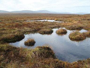
Photo credit: Raymond Flynn, Queen’s University Belfast
Supervisors
Amy GilliganPrimary Supervisor: | Profile: Amy Gilligan Email: amy.gilligan@abdn.ac.uk Institution: University of Aberdeen Department/School: School of Geosciences |
Ray FlynnSecondary Supervisor: | Profile: Ray Flynn Email: r.flynn@qub.ac.uk Institution: Queen's University, Belfast Department/School: School of Natural and Built Environment |
David CornwellAdditional Supervisor: | Profile: David Cornwell Email: d.cornwell@abdn.ac.uk Institution: University of Aberdeen Department/School: School of Geosciences |
Additional Supervisor: | Dr Karen Lythgoe University of Edinburgh Email: karen.lythgoe@ed.ac.uk |
References
[1] Clements, T., & Denolle, M. A. (2018). Tracking groundwater levels using the ambient seismic field. Geophysical Research Letters, 45(13), 6459-6465.
[2] James, S. R., Minsley, B. J., McFarland, J. W., Euskirchen, E. S., Edgar, C. W., & Waldrop, M. P. (2021). The biophysical role of water and ice within permafrost nearing collapse: Insights from novel geophysical observations. Journal of Geophysical Research: Earth Surface, 126(6), e2021JF006104.
[3] Flynn, R., Mackin, F., & Renou-Wilson, F. (2021). Towards the quantification of blanket bog ecosystem services to water (No. 378). EPA Research Report.
QUADRAT Themes
- biodiversity
- earth-systems
- environmental-management
Partners
CASE Partnership with Smart Solo Inc
A CASE Partnership project is delivered in collaboration with an industry partner. The CASE partner organisation contributes finance, expertise, facilities and an internship.

