Project Description
Climate change is having a huge impact on heritage particularly across the northern world as rising sea levels and coastal erosion leads to very significant loss of critical data. One of the most threatened categories of sites are coastal promontories and sea stacks that were utilised as settlements, fortifications and sites to facilitate maritime connectivity from the Neolithic to the medieval period. These coastal sites have never been fully mapped or quantified in northern Britain and some are now just tiny remnants of what were once pivotal locations for coastal life, trade, exchange and interaction. More frequent extreme weather events and sea level rise (predicted to be almost a metre above present levels by 2100 (IPCC 2022)) will have the greatest impact on coastal erosion rates in the coming decades as the intertidal zone extends further inland impacting on a greater number of sites and posing major threat to coastal cultural heritage sites. In that context, coastal promontories are irreplaceable social and cultural resources that provide unique insights into past lives due often to their much better preservation of structural remains and settlement (where erosion has not been too great) than inland areas (e.g. See Noble et al. 2018) yet they are increasingly at risk of being lost to science. Heritage management bodies are only just beginning to develop the tools and quantitative methods to monitor the risks posed to such sites through techniques such as coastal zone assessment and aerial and ground surveys, but these are rarely combined and have never been applied to a complete body of data for a singular dataset. Rarely considered too is the geological substrate (lithologies of cliffs and, bedding and jointing density and orientation, etc) and the impact these factors on past erosion and future survivability. Developing approaches utilising Historic Erosion Modelling utilising SRI ArcGIS 10.5.1. and the Digital Shoreline Analysis System (DSAS) plugin (Himmelstoss et al. 2018); LiDAR and UAV survey, geological assessment, repeated MBES bathymetric surveys around promontories to understand the costal change and seabed morphological evolution, ground-truthing of sites using traditional archaeological approaches such as excavation and geophysical survey, along with GIS analysis and quantification, this PhD will fully catalogue for the first time a heritage resource of over 200 sites, map past coastal change at these, produce condition assessments including geology and develop predictive models for the sites most under threat. At a broad level the PhD will provide quantification of the resource and overall models for future management and mitigation, but in a series of case studies will also quantify loss and threat at the local level providing a unique resource for understanding the threats posed to cultural heritage due to climate change.
CANDIDATE BACKGROUND
The successful applicant should have good skills in field archaeology – particularly excavation, aerial survey and GIS skills for mapping of data. Professional experience in field archaeology is particularly desirable. Experience of Oxcal and radiocarbon modelling would be an additional benefit. Other relevant backgrounds include physical geography, geology and earth science
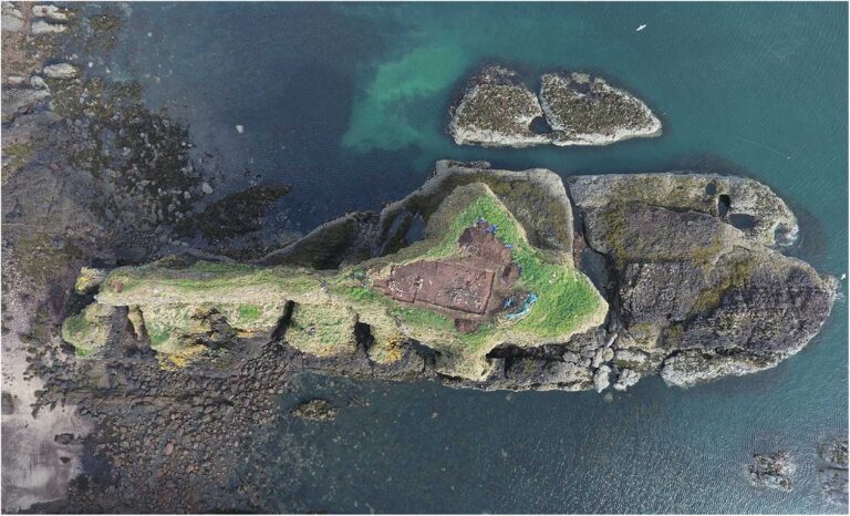
Photo credit: Dunnicaer Hill Fort, Gordon Noble, UOA
Supervisors
Gordon NoblePrimary Supervisor: | Profile: Gordon Noble Email: g.noble@abdn.ac.uk Institution: University of Aberdeen Department/School: School of Geosciences |
Will MegarrySecondary Supervisor: | Profile: Will Megarry Email: w.megarry@qub.ac.uk Institution: Queen's University, Belfast Department/School: School of Natural and Built Environment |
Additional Supervisor: | Dr Michael Stratigos, University of Aberdeen, Geosciences/Archaeology |
References
Himmelstoss, E.A., M.G. Henderson, R.E. Kratzmann, & A.S. Farris. (2018). Digital Shoreline Analysis System (DSAS) Version 5.0 User Guide. U.S. Geological Survey open-file report 2018–1179. Virginia: U.S. Geological Survey.
IPCC (Intergovernmental Panel on Climate Change) (2022). The ocean and cryosphere in a changing climate: Special report of the Intergovernmental Panel on Climate Change. Cambridge: Cambridge University Press.
Noble, G., Evans, N., Hamilton, D., MacIver, C., Masson-MacLean, E., O’Driscoll, J., Cruickshanks, G., Hunter, F., Ingemark, D., Mainland, I., Taylor, S., Wallace, C. (2020) ‘Dunnicaer, Aberdeenshire, Scotland: a Roman Iron Age promontory fort beyond the frontier’. Archaeological Journal, vol. 177, no. 2, 256–338.
QUADRAT Themes
- biodiversity
- earth-systems
- environmental-management