Project Description
The energy transition is upon us as society aims to reduce emissions by transitioning into clean, renewable and carbon neutral energy sources.
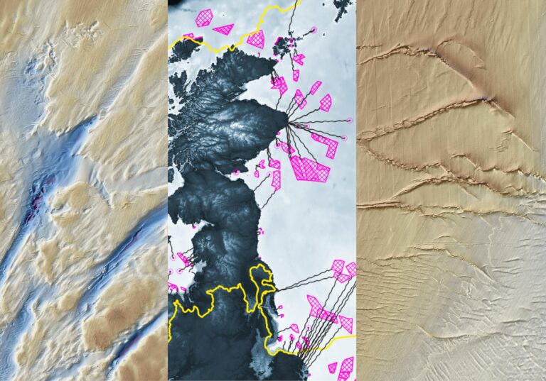
In shelf seas around the planet large areas of the seabed are currently being assessed and evaluated as potential sites for large scale renewable energy developments.. To develop offshore wind farms, tidal turbines and route subsea cables it is essential to understand the seabed conditions and the shallow subsurface to facilitate their construction but also assess the impact on the environment. The challenge is particularly complex on formerly glaciated continental shelves (for example the North Sea) where the geomorphological and sedimentary imprint of last glaciation is intertwined with bedforms generated by ocean waves and currents.
The proposed project will utilise high resolution bathymetric datasets acquired by UK Hydrographic Office (UKHO) and available through the Marine Data Exchange portal to map the offshore geomorphology and sediment distribution around the UK with the focus on areas proposed for Offshore Renewable Energy developments (ORE). Three Key Questions will be addressed by this project:
1) What is it? Bedforms at seabed need to be identified to understand the process of their formation and sediments of which they are composed. Is it a former push-moraine, sand bar or perhaps another glacial bedform modified by currents? At present there is only a very coarse understanding of seabed geomorphology of the North Sea. Detailed mapping will be conducted in GIS environment to understand the detailed landform distribution and its implications for engineering design.
2) What are the metrics and physical properties of the various bedforms? This is key to understand offshore habitats but also to assess the viability of burying cables in the shallow subsurface. This part of the project aims to generate a database of landform-sediment-physical properties based on the results of the detailed mapping by integrating subsurface and seabed sampling information with landform data. It will allow to predictively distribute physical properties of landforms to analogous features that has not been ground-truthed with core or grab sample data
3) Are bedforms mobile? Sediment mobility is one of the key factors when assessing ORE sites both from an engineering and environmental perspective (sediment re-suspension) yet it is poorly constrained, especially in deeper water. Some bedforms may appear to be mobile (e.g. mega ripples or dunes) but have reached their equilibrium and are not moving any more whereas other bedforms may resemble mobile bedforms but are in fact relics of glacial processes. Another aspect that will be fully assessed is the effect that seabed disturbance by foundations or trenching for cables might have on landforms, including relict ones. Repeat bathymetric surveys, hydrodynamic modelling, computational fluid dynamics approach will be used to assess the potential for sediment mobility.
Depending on the student interests the project may focus more on numerical modelling, geophysical investigations or geomorphological or physical and geotechnical properties, though ideally all three aspects will be considered for this research.
CANDIDATE BACKGROUND
The ideal candidate for this position will have a background and/or relevant experience in one of the following: marine geoscience, geophysics, geology, physical geography, oceanography, marine science, engineering geology and/or offshore geotechnical engineering, sedimentology.
• They should have a keen interest in offshore renewable energy and the energy transition
• They should have skills in the use of GIS and/or an understanding of marine geophysical data
• Be inquisitive and a team player
Desirable Criteria:
o Knowledge/understanding of hydrodynamic modelling/ CFD
o Knowledge/understanding of hydrography/marine geophysics
o Knowledge/understanding of offshore geotechnical engineering
o Knowledge/understanding of field measurement campaigns in the marine environment
Photo credit: Marine Scotland
Supervisors
Primary Supervisor: | Dr Bartosz Kurjanski |
Andrew NewtonSecondary Supervisor: | Profile: Andrew Newton Email: A.Newton@qub.ac.uk Institution: Queen's University, Belfast Department/School: School of Natural and Built Environment |
Brice ReaAdditional Supervisor: | Profile: Brice Rea Email: b.rea@abdn.ac.uk Institution: University of Aberdeen Department/School: School of Geosciences |
Matteo SpagnoloAdditional Supervisor: | Profile: Matteo Spagnolo Email: m.spagnolo@abdn.ac.uk Institution: University of Aberdeen Department/School: School of Geosciences |
Additional Supervisor: | Dr Carwyn Frost |
Additional Supervisor: | Dr Dominic Van der A |
References
Mark Coughlan, Marco Guerrini, Shauna Creane, Michael O’Shea, Sophie L. Ward, Katrien J.J. Van Landeghem, Jimmy Murphy, Paul Doherty, A new seabed mobility index for the Irish Sea: Modelling seabed shear stress and classifying sediment mobilisation to help predict erosion, deposition, and sediment distribution, Continental Shelf Research, Volume 229, 2021, 104574, ISSN 0278-4343, https://doi.org/10.1016/j.csr.2021.104574
David B Prior, James R Hooper, Sea floor engineering geomorphology: recent achievements and future directions, Geomorphology, Volume 31, Issues 1–4, 1999, Pages 411-439, ISSN 0169-555X, https://doi.org/10.1016/S0169-555X(99)00090-2
Nanson, Rachel, Arosio, Riccardo, Gafeira, Joana, McNeil, Mardi, Dove, Dayton, Bjarnadóttir, Lilja, Dolan, Margaret, Guinan, Janine, Post, Alix, Webb, John, and Nichol, Scott. (2023) A two-part seabed geomorphology classification scheme; Part 2: Geomorphology classification framework and glossary, Version 1.0. Zenodo, 90pp. DOI: https://doi.org/10.5281/zenodo.7804019
QUADRAT Themes
- earth-systems
- environmental-management
Partners
To be confirmed